
Screenshot of "Aspects of the High Middle Ages" webpage (cropped), 16 February 2017. Content copyright The University of Edinburgh. Top tip: to skip directly to the Margery Kempe animations, click on the third green arrow on the bottom control bar.
I was clicking through the cornucopia that is Google Image Search the other day and stumbled across a Most Excellent Thing. Behold: an animated map of Margery Kempe's three principal pilgrimages! This nifty online resource clearly shows the Englishwoman's movements in three tranches:
- First Great Pilgrimage, 1413-1415
- Pilgrimage to Santiago de Compostela, 1417-1418
- Pilgrimage to Prussia, 1433-1434
It's a really great way to visualise how very far Margery travels, and just how dynamic she is in her lifetime in the pursuit of her spiritual goals. If you'd prefer a static series of snapshots, you're covered by a basic webpage too. Before I found the eminently useful static maps, I actually extracted the Margery maps myself via screenshot, to use as visual aids in a talk on Margery. The fruits of my labour are below as Figs 1-3 - if you use these, please remember to include the appropriate copyright and credit details.
The animations are part of the "Aspects of the High Middle Ages" digital map project, produced by the School of Divinity at the University of Edinburgh. More specifically, the animation credits reads: "Produced by IS Apps Division and the School of Divinity, CHSS for PELF funded grant. Dr K Murray, Dr P Parvis, Dr S Parvis, Dr J Paterson, A Robertson, S Virdi. Copyright The University of Edinburgh." Good work, folks! I really don't know why more people don't know about this excellent teaching resource. Wait, do you know about it? Why didn't I know about it? Sigh. There are so many high-quality innovative digital projects going on right now, but there seems to be a significant problem connecting enthusiastic eye-balls to the actual outputs. There are far too many "hidden gems" that should be front and centre on lists of teaching resources. But anyway, let's get back to the excellent work from Edinburgh.
On top of providing maps showing Margery's travels, the project site also offers further animated maps of:
- the primary routes taken in the First, Second, Third and Fourth Crusade [static images here]
- the vigorous expansion of Cistercian monasteries across Europe, from the Order's inception and Cîteaux Abbey's founding in 1098 to the twelfth century. [static images here]
The primary utility of these visualisations is that they allow the viewer to grasp just how much terrain is covered by the various actors, and in how (relatively) fast a time such coverage was achieved. It offers a nifty way to debunk some common misperceptions of the Middle Ages held by students and non-specialists, e.g. nobody did anything interesting or travelled anywhere further than the next village.
A word of caution, though. To make the most of these, you really need to come at them equipped with supplementary information: mainly specific dates for when stuff happens and context for the little zippy coloured lines between cities and countries. The text version of the cartographic animation supplies useful nuggets to ground appropriate interpretation of the maps, but it's laconic to say the least.
Sometimes, though, precision is not needed. For instance, this past month I gave a public talk to a women's social group in Kent introducing attendees to the majesty, importance, and downright weirdness of Margery Kempe. The maps of Margery's pilgrimages formed a useful talking point. Attendees, who had never heard of Margery before, felt immediately connected with her - and thus more interested in her - when they saw that she visited Kentish towns of Canterbury and Dover in her 1433-1434 excursion(s) (Fig 3) . And seeing that Margery travelled so far and wide across Europe immediately impressed upon listeners that this woman led an incredibly vibrant life, with a devotion to God so great she was willing to risk it all. Not a bad primer at all for diving into Margery's biography, and understanding some of the fascination it exerts upon researchers and readers alike. Digital cartography for the win.

Fig 1. Screenshot of "Aspects of the High Middle Ages" webpage, animation from "Pilgrimages" section (cropped, with annotation), 16 February 2017. Content copyright The University of Edinburgh.

Fig 2. Screenshot of "Aspects of the High Middle Ages" webpage, animation from "Pilgrimages" section (cropped, with annotation), 16 February 2017. Content copyright The University of Edinburgh.
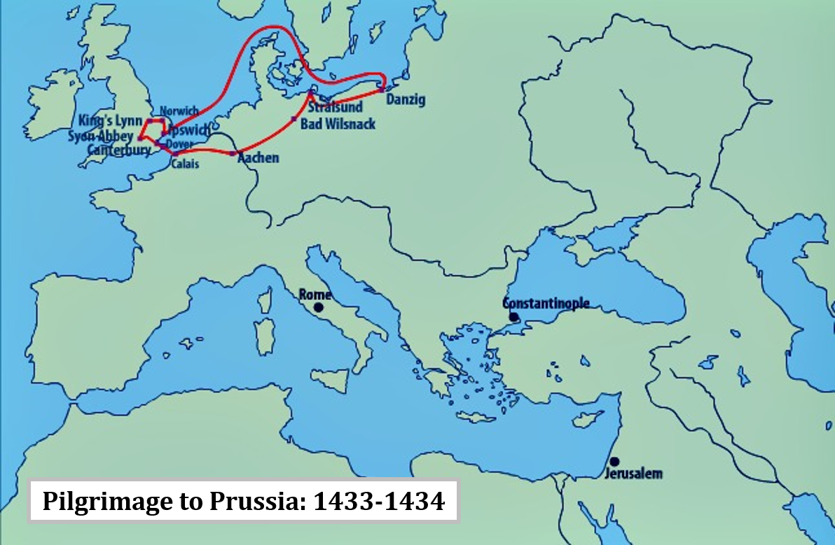
Fig 3. Screenshot of "Aspects of the High Middle Ages" webpage, animation from "Pilgrimages" section (cropped, with annotation), 16 February 2017. Content copyright The University of Edinburgh.